 |
|
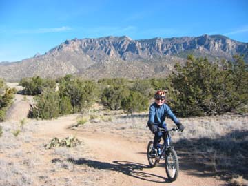
Foothills Trail |
The area is very popular so watch for cyclists, runners, and hikers coming the other way.
The lower N-S trail, #365, is about 6-1/2 miles long, or a 13 mile out and back from south to north and back. The
lower trails are nice cruisers with limited climbing. You can add loops of higher trails that are more technical.
There are several loops of trails that climb to the east boundary and parallel it. The area's only shortcoming
is its popularity, so watch for other cyclists, runners, hikers, and horses. It's great early in the mornings or
in early or late winter when it is too cold to go anywhere else. The trails have signs posted that allow or restrict
bicycles. Water and bathrooms are available at the Elena Gallegos Picnic Area.
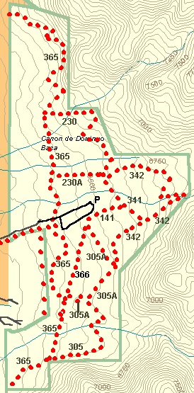
Length: The lower N-S trail 365 is ~6 1/2 miles long. Numerous other loops head east uphill can be added
to lengthen it. (You can cover all the trails in a couple of hours.).
Difficulty: Most of the trails are very clean and easy technically. The lower loop is a nice singletrack cruiser,
of moderate endurance and easy technically. There are upper loops such as the lower Tram tower on the north that
are more technical. There is sand in places and with heavy use more rocks are appearing in the trail than originally.
Trails 341, 342, 305, and 305 are easy single tracks. Trail 230 and the north end of 365 is a little more difficult,
rocky and, steep but still intermediate. There are really no extremely difficult technical trails. The most difficult
trail is the steep Tram Tower trail that takes off east uphill from the northern end of trail 365. There is no
signs but it is a definite turn just before the trail ends.
 |
|
General Trail Map of North Foothills |
- Elena Gallegos Picnic Area. Fee Area: $1 weekdays, $2 weekends. Drive north on Tramway about 1/3 mile north of Academy to Simms Park Rd. It's on the east and there are prominent signs.
- Embudito Trailhead, east of Montgomery and Tramway. Drive (ride) east about 1/2 mile of Tramway on Montgomery. Turn left at the second stop sign onto Glenwood Hills Dr. Drive (ride) north about another 1/2 mile to the Embudito Trailhead road (second right), there is a brown "Embudito Trail" sign, turn right and drive east to a nice parking lot (no bathrooms) where the road dead ends. This area is so popular the parking lot is full on weekends and there are lots of cars parked along the road.
- Sandia Heights trailhead on the north end.
- Take the Bear Canyon Arroyo Trail uphill until it connects with Trail 365.
- Ride from home to the Tramway bikepath, take the trail that parallels the Elena Gallegos / Simms Park Road to the junction with Trail 365 just before the open space entrance building.
- Also, try the pleasant Michial Emery Trailhead where east-bound Spain dead-ends at High Desert Road.